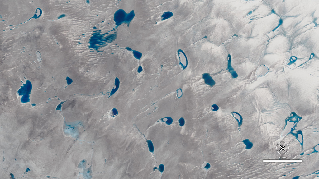
A view of Greenland's ice sheet from the NASA/USGS Landsat 8 satellite showing meltwater lakes on a glacier. (Credit: NASA)
Simple equations are revealing how topography controls supraglacial lake size in Antarctica — and why it matters for climate predictions.
Georgia Tech researchers have developed a mathematical formula to predict the size of lakes that form on melting ice sheets — discovering their depth and span are linked to the topography of the ice sheet itself.
The team leveraged physics, model simulations, and satellite imagery to develop simple mathematical equations that can easily be integrated into existing climate models. It’s a first-of-it’s-kind tool that is already improving climate models.
“Melt lakes play an important role in ice sheet stability, but previously, there were no constraints on what we would expect their maximum size to be in Antarctica,” says study lead Danielle Grau, a Ph.D. student in the School of Earth and Atmospheric Sciences. “I was intrigued by the idea of quantifying how much of a role we could expect them to play in the future.”
The paper, “Predicting mean depth and area fraction of Antarctic supraglacial melt lakes with physics-based parameterizations,” was published in Nature Communications. In addition to Grau, the research team includes School of Earth and Atmospheric Sciences Professor Alexander Robel, who is Grau’s advisor, and Azeez Hussain (PHYS 2025).
Their predictions show that the majority of these lakes will be less than a meter deep and span up to 40% of the ice sheet surface area.
“Many models don’t include any data about lakes on the surface of ice sheets, while others simulate these melt lakes growing until the ice collapses,” Robel says. “Our results show that the reality is somewhere in between — and that the maximum size of these lakes can be predicted using these new equations. This gives us real, concrete numbers to use in climate models.”
From summer project to satellite discovery
Grau first started working on the project as an undergraduate student when she applied for a Summer Research Experiences for Undergraduates program hosted by the School of Earth and Atmospheric Sciences.
Inspired by terrestrial lake research, Grau and Robel investigated the “self-affinity” of the Antarctic ice sheet — a property associated with surface roughness across various scales. For example, a landscape like Badlands National Park, with many rolling hills of a wide range of sizes, would have a different self-affinity than a flat prairie with three large volcanoes.
“A previous study had used this property to predict the size of terrestrial lakes and ponds, and we were curious if we could use a similar approach for supraglacial lakes in Antarctica,” Grau says. “Establishing that the Antarctic ice sheet also has this property was the first step in pursuing this research in more depth.”
The mathematics of melt
Grau continued the investigation as a Ph.D. student in Robel’s lab. Together, they unraveled the physics of how meltwater moves across the ice surface, designing a ‘glacier in a computer’ that mimics meltwater accumulation and movement across various topographies.
“We designed an algorithm and integrated it into a model that the GT Ice & Climate Group has used in the past,” Grau says. “From that, we were able to see how lakes would form on different surfaces across thousands of scenarios. This was the foundation for the mathematical equations I developed, which can predict the lake depth and lake surface area based on the self-affinity property.”
To check their results, Grau enlisted the help of Hussain — then an undergraduate in the School of Physics — to examine satellite data from the Landsat satellite program (which captures detailed photography of the Earth’s surface from space) to measure existing supraglacial lakes and surface topography.
“It was exciting to see how our predictions lined up with what we were seeing in the satellite imagery,” Robel explains. “This shows that our solution is a concrete avenue for climate models to realistically incorporate supraglacial lakes.”
Grau is already working to incorporate the team’s equations into an atmospheric model used by NASA in addition to an ice sheet model developed by the NASA Jet Propulsion Laboratory and Dartmouth College.
“By turning complicated models and satellite data into simple predictive equations, we’re giving climate models a new lens to see the future,” she says. “It’s a small piece of the puzzle, but one that helps us understand how ice sheets respond to a warming world.”
Funding: NASA Modeling, Analysis, and Prediction Program